Going to Extremes on Mount Everest
An ambitious multidisciplinary expedition on Mount Everest included an Apogee SN-500 net radiometer to improve weather monitoring in the Khumbu region. A critical part of the network was making sure the automatic weather stations could 1) cope with the extreme conditions of the region and 2) minimize their weight for quick and easy installations. The research was published in the Bulletin of the American Meteorological Society in November 2020.
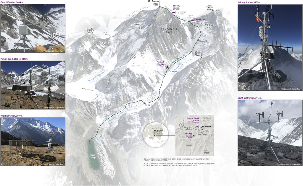
A network of five automatic weather stations (AWSs) were installed during the premonsoon climbing season of 2019, and Apogee’s net radiometer (SN-500) was selected to monitor the site known as the Camp II station (6,464 m). So far, researchers have found the data of the network already offer opportunities to refine the mountain weather forecasting and melt modeling applications.
Read more about the research below.

Figure 1. Map of locations referred to in the text (center). Photographs of the automatic weather stations installed during the 2019 Everest Expedition (left and right). Note the shovel handles used to mount the wind speed sensors on the Balcony weather station (top right).
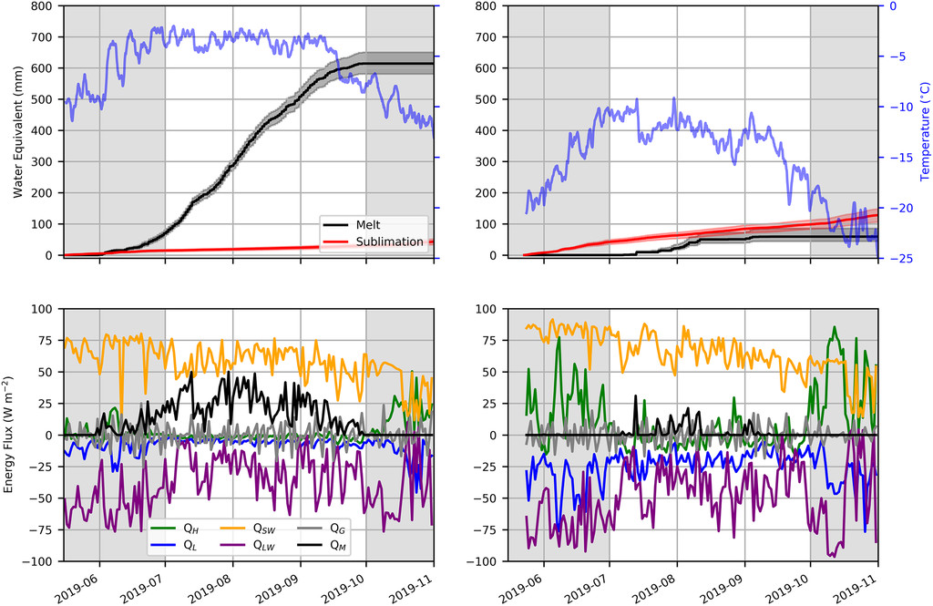
ABSTRACT: As the highest mountain on Earth, Mount Everest is an iconic peak that offers an unrivalled natural platform for measuring ongoing climate change across the full elevation range of Asia’s water towers. However, Everest’s extreme environment challenges data collection, particularly on the mountain’s upper slopes, where glaciers accumulate mass and mountaineers are most exposed. Weather stations have operated on Everest before, including the world’s previous highest, but coverage has been sparse in space and time. Here we describe the installation of a network of five automatic weather stations (AWSs), including the two highest stations on Earth (8,430 and 7,945 m MSL) which greatly improves monitoring of this iconic mountain. We highlight sample applications of the new data, including an initial assessment of surface energy fluxes at Camp II (6,464 m MSL) and the South Col (7,945 m MSL), which suggest melt occurs at both sites, despite persistently below-freezing air temperatures. This analysis indicates that melt may even be possible at the 8,850 m MSL summit, and prompts a reevaluation of empirical temperature index models used to simulate glacier melt in the Himalayas that focus only on air temperature. We also provide the first evaluation of numerical weather forecasts at almost 8,000 m MSL and use of model output statistics to reduce forecast error, showcasing an important opportunity to improve climber safety on Everest. Looking forward, we emphasize the considerable potential of these freely available data for understanding weather and climate in the Himalayas and beyond, including tracking the behavior of upper-atmosphere winds, which the AWS network is uniquely positioned to monitor.

Fig. 2. Simulated mass loss and energy fluxes at (left) Camp II (6,464 m) and (right) the South Col (7,945 m). Cumulative mass losses and daily mean air temperature, with shaded envelope spanning the daily minimum and maximum temperatures (top). The shaded envelope on the melt and sublimation curves indicates the uncertainty from perturbing the roughness length between the 5th and 95th percentiles of values reported in the literature for low-latitude snow-covered glaciers. Mean daily energy fluxes, with notation consistent with Eq. 1 (bottom).
